

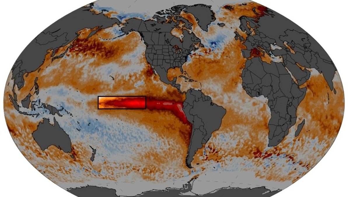

Scientists have warned that super El Nino is continuing to intensify as new forecasts suggest that the climate phenomenon could maintain its grip on global weather well into next year. In this regard, scientists said that the event is now pushing into unprecedented territory, with vast swathes of the planet forecast to experience unusually warm conditions as the Pacific Ocean releases enormous amounts of stored heat.
El Nino to continue strengthening ahead of peak in December: WMO
The World Meteorological Organiation (WMO) in its latest update predicted that El Nino will continue strengthening ahead of a forecasted peak in December. Moreover, scientists said that the powerful climate pattern is likely to influence temperatures and rainfall across much of the world in the coming months.
People in the UK have already been warned to expect large storms this autumn and winter, with the Department for Environment, Food and Rural Affairs urging people last month.
Maps show large areas of globe indicate likelihood of above-average temperatures
This latest warning from the WMO comes as meteorologists share striking maps showing large areas of the globe shaded red, indicating a heightened likelihood of above-average temperatures. As per the latest updates from the WMO, there is a near-100 per cent chance that El Nino will persist through February next year. In the meantime, US meteorologist Ryan Maue called the outlook in a post on X, writing: ‘New maps show Earth almost entirely in the red.
UN says this year’s weather phenomenon could be strongest since 1950
Moreover, the warnings come as the United Nations called this year’s weather phenomenon could be among the strongest witnessed since at least 1950. The World Meteorological Organisation (WMO) also stated that El Nino will compound the effects of man-made climate change. Apart from this, the experts are also saying a large area of planet Earth will experience unusually warm conditions as the Pacific Ocean releases enormous amount of trapped heat.
Here’s what climate scientists have to say
Meteorologist Ryan Maue shared a climate map of the entire planet, saying the Earth is almost entirely in red. “El Nino continues at “maximum power” into the winter with planetary heating dialed up everywhere EXCEPT the United States,” he further said on X. He also agreed with the WMO assessment that El Nino will persist through February 2027.
Another climate scientist Zeke Hausfather said in a post on X, “This year’s El Nino continues its climb into uncharted waters; Nino3.4 region anomalies are now at a 3.4 degrees Celsius above normal (how fitting!), higher than any prior El Nino event on record.”
The WMO in its latest forecast said that there is an overwhelming likelihood of above-average sea surface temperatures across large parts of the globe during the final months of 2026.
The WMO further added that sea surface temperatures in the central and eastern tropical Pacific, the region at the heart of El Nino phenomenon, were expected to reach a record 3.7 degrees Celsius (6.7 degrees Fahrenheit) above normal from October to December.
What is El Nino effect?
It is worth noting that the El Nino is the warm phase of the naturally occurring El Nino-Southern Oscillation cycle, a climate pattern that influences weather around the world. This effect tends to cause higher global temperatures and disrupt rainfall patterns across large regions – meaning drought in some areas and heavy rains in others and typically occurs every two to seven years.
Also Read:
‘Strongest El Nino in a century’ could drive global temperatures higher: How will it impact India?